Notice. New forum software under development. It's going to miss a few functions and look a bit ugly for a while, but I'm working on it full time now as the old forum was too unstable. Couple days, all good. If you notice any issues, please contact me.
I'm Bob Moore, high altitude kite nut. I led a team of kite enthusiasts on a quest to break the world altitude record for a single kite. In 2014 after ten years of nearly annual treks to a western NSW sheep station, we broke the World altitude record for a single kite with a flight to 16,009 ft. above the launch point. This altitude was ratified by Guinness World Records http://www.guinnessworldrecords.com/world-records/highest-altitude-by-a-single-kite/ and The Australian Book Of Records http://www.theaustralianbookofrecords.com/r314-world_altitude_record_for_a_kite_-_16010_fee.php http://www.kitesite.com.au/kiterecord/index.html Initially electronics was a peripheral issue in respect to high altitude kite flights. However, it is now among the most important factors for high altitude flights, especially in measurement and verification of altitude and the enhancement of data collection. It now may be increasingly used to enhance flight performance for future attempts on the kite train record. In 2004, when I made my first series of test flights at Cable Downs, a 50,000 acre sheep station near Cobar in Western NSW, I used a Garmin Geko hand held GPS unit on-board a 12 sq. metre kite. In April 2005 I used a Garmin Geko a combination of Laser and optical theodolites to measure kite altitude. Theodolite measurement was abandoned due to technical difficulties and the realisation that cloud could often render this technology useless for measurement of kite elevation. In September 2005 I used a 161 MHz animal tracker with a Yagi antenna to track kites. It was unsuccessful due to the distance and terrain. In September 2007 I employed GPSFlight telemetry to track kites in real time for the first time. This system consisted of an on-board Garmin 15L GPS receiver connected via an interface board to a Maxstream 900 MHz radio transmitting over ranges of up to 40 km at 100 mW. The base receiver was a Maxstream (now Digi) Xstream unit connected via USB to a laptop running proprietary software on Windows XP. Later I upgraded to a Windows 7 laptop running a more advanced version of their software. From 2007 I used the GPSFlight telemetry and a Garmin eTrex H unit as a backup data logger. You can see the year by year progress of the record attempts on the above site. The GPSFlight telemetry modules were initially unreliable but the last version is pretty good. The GPS flight modules have an advantage over others in that they have the ability to track multiple units simultaneously. They do this by using a unique identifier for each unit. I never needed this feature so it's a moot point. Unfortunately the GFC killed GPSFlight plus their initial unreliability may have turned some customers off. In 2013, I acquired new GPS telemetry and a GPS data logger. BRB and TLA are both niche products for hobby rocketry tracking. Big Red Bee is a 900 MHz GPS telemetry system. http://www.bigredbee.com/ as is Tragic Little Aerospace. Unfortunately the latter system seems to have died along with their web site. In any case I have yet to use either of these systems on high altitude flights. The Holux data logger I used on the 2014 World Record Flight captured all the flight whereas the GPSFlight module stopped transmitting at the 65% flight time. The Holux GPS data logger broke at the USB cable connection. However, the features are good and the performance excellent so I recently purchased a replacement. I have purchased several other GPS data loggers including Tripmate 852's and a Canmore (Canway) data logger. I will now have 3 of almost everything during record attempts including 3 kites, 3 x 12 km line, strobe lights, GPS Telemetry, data loggers and spares. The kite record has unexpected outcomes with interest from several groups researching Ion Power generation. I am pleased to be included in their consultative team. https://ionpowergroup.com/contactteam/ I am here because I lack the expertise to incorporate some new electronic gizmos on my high altitude kites. These may include, mechatronics for enhanced flight performance, easier kite retrieval, additional data collection and reduced power consumption for longer flight times. I will be asking you guys a lot of questions. I hope you don't mind sharing your knowledge. I have engaged Dave Thompson in New Zealand to repair some of my stuff and he may have a go at some board development. He led me to this forum. Coming up in the next 18 months are test flights of kite trains to 20,000 ft and then in a few years, a big train to 40,000 ft perhaps.
Catch you later.
Bob Moore
brucedownunder2 Guru Joined: 14/09/2005 Location: AustraliaPosts: 1548
Posted: 03:21am 25 Jan 2018
Copy link to clipboard
Print this post
Hi Bob , very interesting ,,,sure beats my butterfly collecting !!.
I,m intrigued at one thing ,maybe many,but this one thing comes to my mind first, How heavy is 6,12Km whatever length of line ?? Is it fishing line ?
the line must be nearly horizontal for a fir distance ,can you explain?
Hey, lot of questions come to my mind ,what the kite made of ?
interesting , good luck with your hobby .
BruceBushboy
Tinker Guru Joined: 07/11/2007 Location: AustraliaPosts: 1904
Posted: 09:39am 25 Jan 2018
Copy link to clipboard
Print this post
16,000 feet? that's a long way up, do you have to notify the aviation authorities and fit radar reflectors on it?
A picture of such a kite would be interesting.Klaus
Thanks for your interest Bruce. Most of the info is on my website and the link is above. Early on in development of high altitude kite flying I realised one of the critical issues, if not the most critical issue, is flying line. I quickly understood that the main limiting factors to kite altitude were line diameter and line weight.I needed the the thinnest, lightest line available. Braided UHMWPE lines are the thinnest,lightest and weight for weight, the strongest lines in the world. The Ultra High Molecular Weight Polyethylene fibre was developed by DSM Dyneema in the late 70's. Honeywell in the USA were licenced to use DSM Dyneema's patented gel spinning process which is similar to how spiders spin web.It has been refined over the years to produce several versions of these ultra strong micro-fibres. I mostly have used Dyneema line and I was sponsored by DSM Dyneema from 2009 - 2014. I used 200 lb breaking strength Spectra line from the USA in 2004 but have since not used it although it is part of 12 km backup line sets for future flights. Dyneema and Spectra are the main fibres used in high strength braided fishing lines. My 26 km of Dyneema lines were made in France by Cousin-Trestec and range in strength from 91 kg to 250 kg. Their diameters are extremely thin at 0.7 mm to 1.2 mm. Kevlar, is 10% thicker and 40% heavier. I don't use Kevlar for several other reasons. Dyneema line has an specific gravity of 0.97 so floats on water. The point of having thin line is to minimise aero drag and of course the lighter the load the kite carries, the higher the altitude. Depending on the line thickness and strength, the weight will be between 300 and 1,000 grams/1,000 metres. The total line weight released on the record flight was about 5,800 grams. About 65% of the line's weight is supported by the kite and about 70% of the line's aero drag. Interestingly, a double size kite requires double strength line but double strength line, although double the weight, is only about 50% thicker due to the ratio of area to diameter being governed by Pi x R SQ. Thus the kites size to line drag ratio improves as kites get bigger. The air density decreases with altitude and so the kites lift although, on average the wind speed increases to more than match the decrease in air density. The kites lift increases at a lower rate than the load it has to carry with line weight and drag. The structure of lines varies depending on the number of fibres in each weave (fibre bundle) and the number of weaves. Braided line may be 4, 8, 12 and 16 weave depending on the manufacturer and price point. There are a large number of counterfeit lines made in China and can be seen on eBay. These lines are often made from inferior fibres with poor consistency and lower than claimed breaking strengths. High quality lines always break at or above claimed strengths and are pre-stretched during manufacture to produce the thinnest most compact lines. Where possible I stipulate the longest line lengths without spliced joins. Because the lines are a hollow braid structure, they can be joined by using a "Chinese finger trap" method to provide joins that are equal to or exceed line strength. I use special splicing needles to insert one line inside the other and vice-versa. Dyneema line has a very low friction co-efficient so that it cannot be flown by hand when attached to anything more than a relatively small kite. While it is extraordinarily strong, abrasion resistant, UV resistant and tenacious, it's Achilles Heel is it's low melting point. I had to design the winch carefully to avoid sliding contact with fixed guides and employ pulleys wherever possible. The kites are made from rip-stop nylon and fibreglass tube. Their span is 6 metres and height 2.8 metres. The total lifting surface is 12 sq. metres. Larger framed kites are feasible but para-foils may ultimately fly the highest. Mike Richards, one of the team members and owner of Kite Magic in Coogee, builds the kites. The fibreglass tubes are 15 mm OD and 12.5 ID. They are very light, strong and resilient. None have ever broken although a kite has been ripped beyond repair by gale force winds. The line payout is measured with a modified land distance wheel which is calibrated with a digital cycle meter. It's accuracy is about 99.99%. The winch is powered by a 1.1 Kw Teco AC motor through a TECO FM 50 inverter/controller. It is able to handle up to 150 lb line tension with a 40-1 reduction pulley set. The maximum line speed with this ratio is 12 kph but this is with the motor RPM at 6,000 which is not sustainable for more than 1 minute before the motor controller shuts off to protect the motor. After all, it is a 2850 motor. It does operate for extended periods at about 4,000 rpm. This TECO stuff is great. This is the 3rd motor. The first was under powered and burned out early in the record attempts. The second 0.72 kW motor met it's limit with 120 lb line tension. I will use it in tandem with the 1.1 kW motor during the upcoming train tests. It will be interesting to see how single pots and switches control 2 inverters and motors simultaneously. Line tension is measured with a hydraulic gauge made by engineer, Doug La Rock in the USA. I have fiddled around with load cells lifted from digital scales but it is an unfinished project. If I were able to complete these I could measure line tension at the kite and make it part of enhanced data collection in real time via telemetry. Getting back to the above questions, given sufficient wind, the kite starts out at a flying angle of about 70 degrees from horizontal. Sometimes it goes vertical or even beyond. We attach a small drogue (drag cone) to the back of the kite to keep it well behaved although the DT Deltas we use are ultra-stable. The line, just after launch is virtually straight and as the kite ascends the line gradual develops a sag due to weight but mostly due to wind drag. The sag was only about 10 deg. at maximum altitude so kite was at 25 deg and line at 15 deg. On that day the maximum altitude was 16,009 ft. above the launch point. Close to ideal conditions saw this world record altitude. On other days the kite may max out at 10,000 ft. with the kite at 35 deg but the line is dragging in tree tops at 5 deg. In the first case, further release of line did not result in increased altitude. In the second case, further release of line resulted in loss of altitude.
I have a link to my site in my post above. Plenty of pictures there. Look at the page on CASA. I have 5 YouTube videos which record progress fro 2007 to 2014. Just search for kite altitude record. The process of getting Civil aviation Safety Authority approval was long and difficult initially but now I have established my reliability and credential, it is routine. It costs about $560 for the CASA application for each series of attempts which usually last a week. I am restricted to a zone well away from air traffic and have lots of conditions to adhere to.
When I was contemplating using direct measurement of the kite's altitude with laser, I needed to put small aluminium target disks on the front of the kite to reflect the laser beam. There are a number of reasons why I didn't go with this technology including cost, aero drag and cloud cover. Laser units with a 20 km range are military grade and were about $50,000 plus it was doubtful I would ever get a licence to operate it in Australia. I did use a Pentax Laser theodolite in 2005 to survey observation points for future optical theodolite measurement. We were to measure kite's altitude using triangulation. You can see the calculations required on the site's theodolite page. It was interesting seeing the 4 km laser beam from the Pentax. Centimetre accuracy over this distance is impressive. However, we couldn't go ahead with this method because, surprisingly, even in a semi-desert zone, clouds would frequently obscure the kites and block the laser. Radar is not used in this remote zone at this altitude as it is uncontrolled airspace below 20,000 ft. Even if it were, the kites are virtually radar transparent. The only radar would be on the occasional commercial jet flying over 14,000 ft. above the kite at 30,000+ ft. As well as a very weak or non-existent radar signature, anything that was picked up would be lost in ground clutter. The record attempts were conducted in a protective zone created by the Civil Aviation Safety Authority. This consisted of a 30 km x 20,000 ft cylindrical zone centred on the Cable Downs air strip. Pilots in any aircraft such as domestic jets, modern twin engined aircraft and military aircraft would get an automatic instrument warning of a "NOTAM" zone (Notice To Airmen). In 8 record series I had two requests for a fly-through and one incursion by a light aircraft. It is a very lightly trafficked area.
I am not a total electronic klutz but I don't have the knowledge or expertise to design and build any of the electronic devices for my high altitude kite flights. I know what I want and I will describe what I have. I want to continue to measure and record altitude with GPS. This is done at the moment with GPS telemetry. The main GPS telemetry system I have been using is GPSFlight. They went bust by 2011 due to the GFC but partly due to lack of reliability of earlier units. A second version I got in 2008 has been fairly reliable and is still currently working. However, it does have pins for collecting other data such as temperature and humidity but there are no schematics for the transmitters and interface board. The Maxstream (Digi) ground transceiver is busted and will be replaced by a new unit.https://au.mouser.com/ProductDetail/Digi-International/XM-M92-UP-AA?qs=sGAEpiMZZMuIes%252bYBRf57RVakCPprhTH%2feSu6t kB9gL58IHqv8KbhA%3d%3d The GPSFlight system was not cheap at over $600 in 2006. This the link to GPSFlight on Wayback internet archive :https://web.archive.org/web/20120210201433/http://www.gpsflight.com:80/transmitters I have 3 other GPS telemetry units. BRB (Big Red Bee), TLA (Tragic Little Aerospace) and egg-finder. http://www.bigredbee.com/brb900.htm http://www.therocketdoc.com/gps-systems.html http://www.eggtimerrocketry.com/page45.php Eggfinder is a kit build which Dave Thompson just sent back to me with a nice custom made case for the LCD receiver. I only have to build an enclosure for the transmitter including an insulated battery housing. Making the enclosures durable and weather proof is very important for the board's and batteries survival at very low temperatures. These systems are "900" MHz systems intended for model rocketry but are capable of tracking line of sight airborne objects to at least 20 km and up to 60 km. The 900 MHz is nominal as the units are set between 915 and 925 MHz. each mfg has to get certification for their radio telemetry before importing to Australia.They are licence free devices. The GPSFlight unit was claimed to have a range of 40 km and more. The TLA and BRB systems have never been tested on high altitude kites. The BRB transmitter is currently being repaired by Dave Thompson in New Zealand but may have to be returned to BRB in the USA for repair or replacement. None these units are capable of additional data transmission as far as I am aware. TLA seems to have disappeared and the site is no longer available. That is one of the issues with these niche electronics products, especially for hobbies. The small market does not outweigh the development costs and continued low volume production doesn't give the returns. If you look at the GPSFlight system they put in a lot of effort and thought to the development of the boards and in particular, the software. The one issue which let them down initially was board engineering and reliability IMO. By 2008 they had sorted a lot of those issues but it was too late to recover before the GFC hit. So, I know what is needed to make a reliable, robust and comprehensively featured GPS telemetry system but I have little idea about the mechanics of designing or making such a system. Of the 4 telemetry systems I have, 2 are no longer produced or supported and the BRB and egg-finder are in the same class of niche hobby rocketry tracking. I think it would be better to help someone in Australia or New Zealand make our own systems because these other systems may be here one year and gone the next. Some of you may know of Dave Thompson, the repairman from Silicon Chip Magazine's Service column. He runs PC Anytime, a Electronics repair business in New Zealand. He is prepared to reverse engineer the 2005 GPSFlight module but has some reservations about wiping the chip and killing it. For me, it's practically dead anyway so there is nothing to lose. Another option is to go with Arduino and use the various shields and modules to build a GPS telemetry system which includes the other functions I am interested in. Hello Back Shed people, I'm here to drain your brains! (:
Could any of you guys look at this site and give an opinion if the tech this guy is using could be applied to my kite tracking? Thanks. http://www.loratracker.uk/wp-content/uploads/2016/06/Semtech-LoRa-Transceivers-%E2%80%93-a-KISS-approach-to-Long-Range-D ata-Telemetry-January-2015.pdf
If this thread needs to be transferred to a more appropriate place then that would be good.
Bob Moore
isochronic Guru Joined: 21/01/2012 Location: AustraliaPosts: 689
Posted: 07:17am 28 Feb 2018
Copy link to clipboard
Print this post
Could a kite get up to the jetstream do you think? It may have to be balloon assisted to get there I guess.
We flew our big kite into a low level jet stream in western NSW in October 2005. The wind speed was too much. The motor burned out trying to retrieve the kite in winds that were over 60 knots(120 kph). The kite was then lost overnight due to line breakage. This jet stream started at 5,000 ft and went to about 20,000 ft. Normally jet streams occur between 30,000 and 40,000 ft. They can be used by pilots to decrease aircraft travel time and fuel consumption. The winds required to fly our kites reliably are between 10 and 30 knots (about 20 and 60 kph ground equivalent). Any less and flight cannot be sustained with increasing weights of line above a few thousand feet and any more and the kite becomes distorted, loses efficiency and may be damaged. Jet streams are just too powerful for conventional kites. It may be possible to design kites that can tolerate the winds encountered in jet streams but it is very difficult to design a kite that can fly in light winds and really strong winds as well. We don't use balloons to augment kites as then it's not a kite but a Kitoon or if separate but attached entities, a balloon assisted kite. There is no record category for balloon assisted kites or kitoons. Jet streams cannot be predicted with any degree of certainty although they tend to occur over Australia with high pressure systems and are often present with high altitude cloud such as cirrus and a strong west to east high altitude air flow. Jet streams can persist for a few days, oscillating like a snake at high altitude. Winds as high as 300 kph have been recorded in jet streams. The highest official altitude by a kite was in 1919 at Lindenberg at a weather station. The team reached 31,955 feet with a train of 8 kites. There are reports of a flight to over 37,000 ft but the records are buried in German government archives. A group of US high school students claim to have flow a train of 19 plastic Gayla bat kites to over 35,000 ft. in 1969. I very much doubt this claim although it did appear in The Guinness Book Of Records, it has since been removed.
I have dropped plans to attempt a world record altitude for a train of kites. I was half way into preparation but had to stop because of health and finance. I guess I'll have to stick to mucking around with stuff in my shed. I'll still be building kites and flying them at festivals.
With improved health I have reactivated plans for more record attempts. Tentative dates are for 1 week in August over the next four years. A 223,000 acre (103 hectares) property has been secured for the high altitude flights. The team is back together and the 4 of us will be meeting soon to toss around some ideas such as improved kite designs, telemetry and flying line. The GPS telemetry issue remains unresolved, with 2 non-working systems and 2 untested systems. Basically I only have GPS telemetry design by rocketeers for rocketeers although in theory, these units should work to 30+ km ranges. GPS data logging is no problem with Garmin, Trip mate 852, Holux and Canmore units with a total of 11 units as auxiliary and backup units. I am investigating the feasibility of building a 902 - 928 Mhz System based on Arduino so that additional data logging functions can be incorporated. I have contacted Keith Rippon, an Australian who specialises in board kit assembly and board design. I have asked him top trouble shoot/repair the two malfunctioning Systems as well as assemble some Eggfinder units. I would also see if he would consider developing our own GPS telemetry system, perhaps using Arduino, perhaps not. There are plenty of GPS receivers and Digi make a range of radio transceivers. Anyone with GPS telemetry experience is welcome to comment please.
Oh, I forgot to mention, the targets are 25,000 ft. for a single kite and 40,000 ft. for a train of kites.
Bob Moore
dwyer Guru Joined: 19/09/2005 Location: AustraliaPosts: 575
Posted: 04:03am 01 Apr 2019
Copy link to clipboard
Print this post
Hi Bob i love flying kite many years ago around the year 1958 as use to make kite out of news paper and homemade corn starch to make glue and only string i use Do you have any picture of your kite
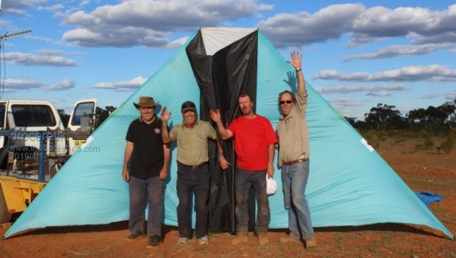
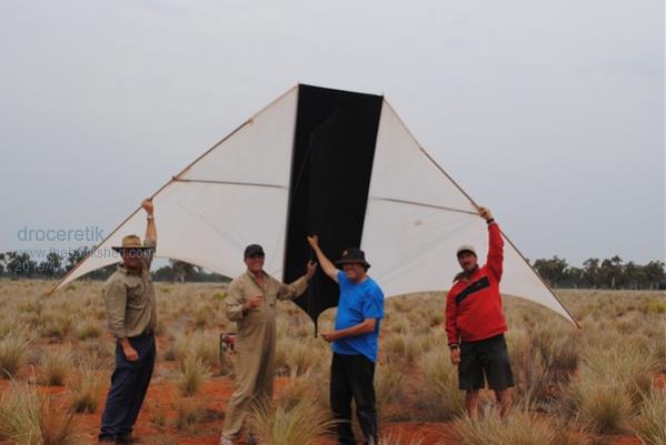
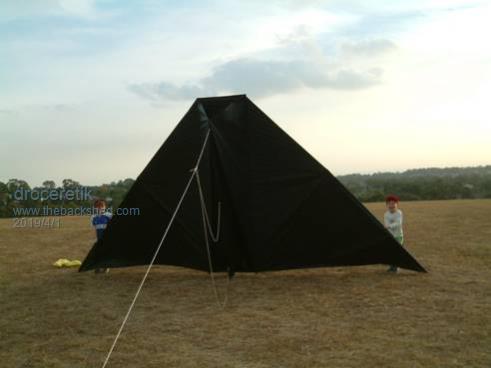
Yeah, kites are on my web site at http://kitesite.com.au/kiterecord/High_Flying.html but here are the main kites used for the record attempts. They get a bit worn in that harsh environment and get a bit frayed in high altitude winds so we replace them in time. Apart from one special larger kite, they are all 6.4 metre span, 2.8 metres tall and have an effective sail area of 12.34 sq. metres. The original black kite on Rooty Hill in Western Sydney behind the red Nissan. http://kitesite.com.au/kiterecord/Testing_2004.html
The same kite with my two young sons either side. http://kitesite.com.au/kiterecord/April_2005.html
The black and blue kite was a one off at was 16 sq. metres http://kitesite.com.au/kiterecord/Kites.html
The black kite was lost in the wilderness in October 2005. Here is the blue and yellow version in April 2007. http://kitesite.com.au/kiterecord/April_2007.html
The blue and yellow kite was retired due to damage and the next was black and white kite which was snapped from an on-board camera on a smaller kite over the airstrip at Cable Downs. http://kitesite.com.au/kiterecord/April_2009.html
This kite flew for several series of attempts and reached over 10,000 ft on 2 occasions including a break away that was recovered by mine workers 20 km away. The white and black kite was damaged in gale force winds in 2011 then the damaged blue and yellow kite was repaired and resurrected and reached 14,119 ft. http://kitesite.com.au/kiterecord/September_2011.html
The turquoise and black World Record kite was first used in 2011 after the death of the white and black kite. Here it is in 2014. https://www.youtube.com/watch?v=IG_Y9ESbS4c&t=10s
New versions of the same basic design are planned for future attempts. See them near the bottom of the News page. http://kitesite.com.au/kiterecord/News.html
Have a look at the GPS page. that's the main reason for being here is to brain storm GPS telemetry on Arduino. If any of you lovely people feel incline, go to the GoFundMe crowd funding site and navigate the Kite Altitude Record page. Any donations would be very welcome as I am now a pensioner with a very limited life span. I wish I had started this quest 30 years ago when I was healthier. (and richer ) BTW, How Do They Do It? commissioned and produced on the Discovery Channel and made by WAG Television, is including some of our YouTube footage on their program on kite building in Malaysia. They are also keen to do a dedicated program on our Kite Altitude Record.
Sorry, I thought the links I provided were clickable but you can just select cut and paste. I'm not familiar with the widgets on this site. I just wanted to upload some images and now I see the upload images button but I'll leave that voluminous post as is.
Bob Moore
Tinker Guru Joined: 07/11/2007 Location: AustraliaPosts: 1904
Posted: 10:34am 01 Apr 2019
Copy link to clipboard
Print this post
Bob, on the message header, fourth from left, is an icon that looks like a globe wearing goggles. Click that and follow instructions. You can test if you done it right by using the 'preview post' feature at the bottom of the message box..Klaus
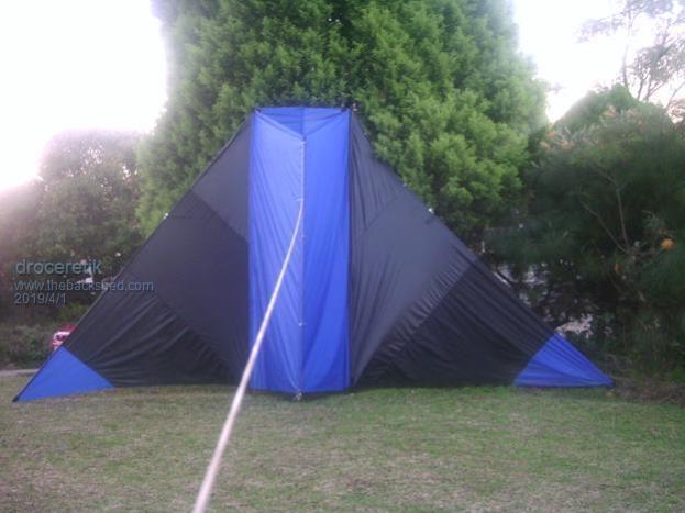
A 16 sq. metre version in my front yard at Baulkham Hills
Cable Downs 2012, just before this kite was destroyed by gale force winds
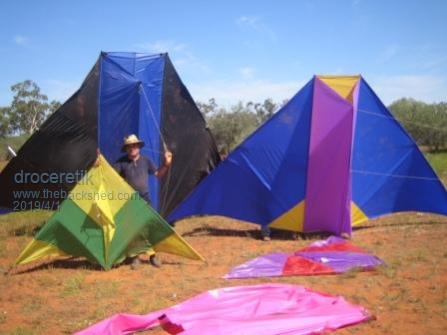
Cable Downs 2005 with the 16 sq. metre and 12 sq. metre DT Deltas plus a "small" delta. The big kite only flew to 6,500 ft. and was just too flexible with cheap material and thin spars. The blue, yellow and purple kite flew to 14,119 ft. in 2011. The green and yellow delta flew to about 3,500 ft but should be capable of about 5,000 ft
On the top of Rooty Hill in Western Sydney with my two young sons, 7 & 5 in 2004 and it was the first version of our record kites. This one was lost in the wilderness in October 2005.
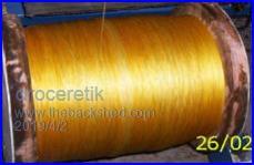
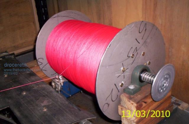
This my "ball of string" a 12,400 metre reel of UHMWPE braided line, otherwise known as Dyneema. I was sponsored by DSM Dyneema with 32,000 metres of various strength lines manufactured by Cousin-Trestec in France with fibre supplied by DSM in Holland. The value of the line is conservatively estimated at $15,000.
This is 300 lb line from Amika in Taiwan. The fibre was supplied by Toyobo in Japan, licenced by DSM Dyneema to produce fibre under the Dyneema brand. This line was 0.8 mm thick. This was some of the line supplied by Cousin-Trestec and was 6,200 metres of pink line underlain with 6,000 metres of the above yellow line. It's 0.0.62 mm thick and hard to believe it is 180 lb breaking strength. These lines are the main reason for breaking the World record with a relatively small kite. The previous record was 2,500 ft lower with a kite 2.2 time bigger using Kevlar line triple the weight and double the thickness. There was even a guy in the USA who made his own line with a second hand industrial braiding machine. He made 2,000 metres of 410 lb braided Spectra for me. I contemplate purchasing my own machine but $20,000 was a bit much for my budget.
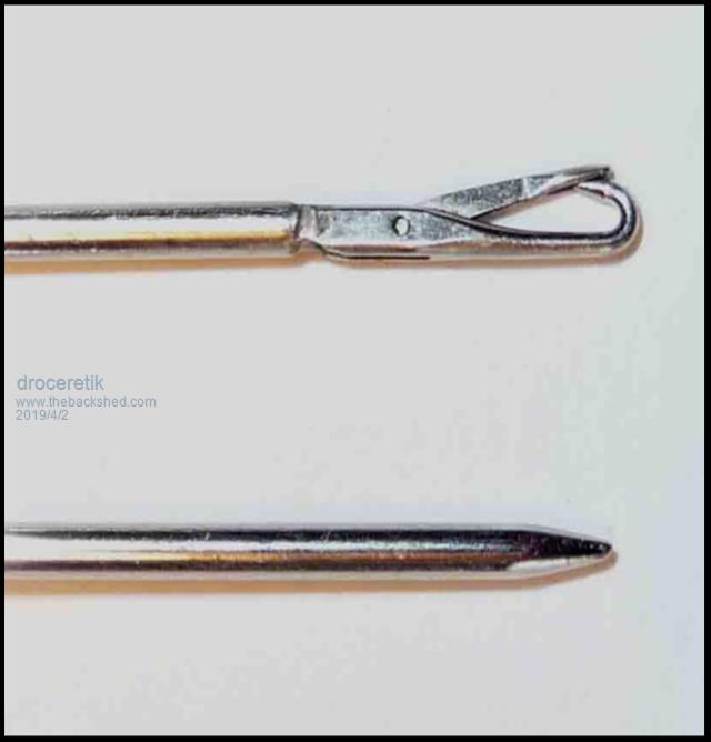
Lines never joined with knots which weaken the line. I always used splices and these Daho needles are expensive excellent. I learned so many new skills such as sewing, pattern making, splicing, soldering, welding, applique and numerous other things for this kite record. All up I accumulated about 50,000 metres of various line over 15 years. I had to build a 5 x 8 metre shed to house kites and kite building materials Then another shed to house my regular tools, then a work port to house all my big machines and trailer then I have my workshop. I have a front shed, side shed and a back shed plus a workshop. No wonder my wife just shakes her head sometimes. The one thing I can't quite get my head around is electronics and soldering.
Tinker Guru Joined: 07/11/2007 Location: AustraliaPosts: 1904
Posted: 10:15am 02 Apr 2019
Copy link to clipboard
Print this post
Interesting pictures, thanks for posting them. Those kites are nothing like I had imagined, I suppose that shape was conceived by experiment? What other purpose has that curious triangular box under the kite beside the 'string' attachment?
I would imagine you launch that kite from the back of a ute, similar as they launch gliders? Then, when it flies you let out more string. What happens if the wind direction high up is different from that at lower altitude? Do you have to re position the string drum to have an even pull on it? What angle to the ground is the string when the kite is at max altitude and how much pull load is on the string? I suppose the reel is motorised to wind the kite back down to earth. Hopefully that are not too many questions. Klaus
Page 1 of 2
Print this page
The Back Shed's forum code is written, and hosted, in Australia.


 Do you have any picture of your kite
 )
)