
|
|
Forum Index : Microcontroller and PC projects : Micromite climbs to 25,777m
| Page 1 of 2 |
|||||
| Author | Message | ||||
| edu001 Regular Member Joined: 14/07/2014 Location: United KingdomPosts: 82 |
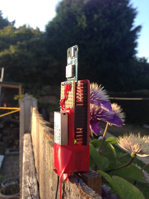
EDUPIC1 High Altitude Balloon tracker first successful flight completed 44 pin Micromite Lite from micromite.org uBlox Max8 GPS module Radiometrix RF Transmitter DS18b20 Temp sensor Single 1.5v AAA Lithium Energiser Battery The DATA is compiled into a string and transmitted in RTTY over RF in the following format $$EDUPIC1,941,12:59:55,5141.98759,00133.86900,09,18493.3,0,- 31.5,1.3*C538 $$payload,count,time,lat,long,sats,alt,flightmode,temp,batte ry volts,crc Suspended on a small helium balloon it reached an altitude of 25,777m and a temperature of well below -30 degrees Another flight is planned in the near future to an altitude of 36,000m + Thanks to the WhiteWizzard for his invaluable assistance with coding :) 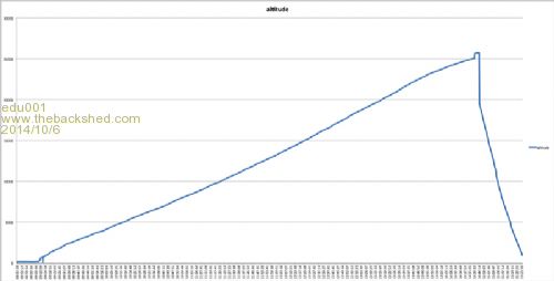
|
||||
| plasma Guru Joined: 08/04/2012 Location: GermanyPosts: 437 |
Yea , i like this idea ! |
||||
| viscomjim Guru Joined: 08/01/2014 Location: United StatesPosts: 925 |
This is very cool. Even cooler would be more details on your interfaces and maybe code so we can learn from your great project. How exactly do you recover this and how long a trip (time wise) is this? Are you logging the data into the uMite and how much data (how many samples over how much time?). I bet this is the furthest away from earth a uMite has ever traveled.... unless air shipping to US the plane probably goes higher, but the uMite isn't running... Great Job!!!! Edit... How did you mange to use one 1.5v battery, boost converter??? |
||||
| edu001 Regular Member Joined: 14/07/2014 Location: United KingdomPosts: 82 |
I will post more detail later today Here is the received DATA over time for 1 flight 2014-10-06_151046_EDUPIC1_Example.zip |
||||
| edu001 Regular Member Joined: 14/07/2014 Location: United KingdomPosts: 82 |
Yes just a 1.5v to 3.3v stepup |
||||
| atmega8 Guru Joined: 19/11/2013 Location: GermanyPosts: 738 |
He talked about > 25.000 meter, not feet ;-) |
||||
| mindrobots Newbie Joined: 21/05/2014 Location: United StatesPosts: 32 |
Wow! 84,570 FEET - for those of us State side that don't talk meters! That's 16 miles up in the air! Great project, thanks for sharing! |
||||
| viscomjim Guru Joined: 08/01/2014 Location: United StatesPosts: 925 |
Holy Cow that awesome. Looks like 6.5 hours flight time? Which radiometrix transmitter gave you that range on small powersupply and what did you use for a receiver? Also, do you need any kind of agency clearance to let a balloon go like that? I looked at your flight information zip file. How do the lat and long numbers work? I tried to google the numbers but had no luck. super impressive!!!!! |
||||
| edu001 Regular Member Joined: 14/07/2014 Location: United KingdomPosts: 82 |
Some more details on the tracker The setup is ublox GPS connected to COM2 Radiometrix MTX2 transmitter connected to COM1 I read the correct NMEA sentence from the GPS filter out the unwanted fields/sentences and compile it into a string which is sent to the MTX2 for transmission on 434Mhz a 10mw signal can be received over hundreds of kilometers There are quite a few receiving stations all over europe we decode the RTTY using fldigi software and send the data over the net to Spacenear.us check it out it will all make sense The balloons are quite small this one is a foil 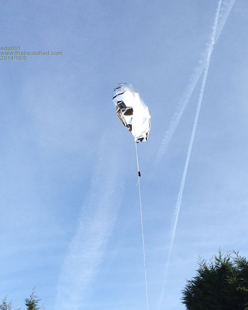
Launched on Saturday it covered 822km at 7000m ill post the details on that flight as soon as I have the data |
||||
| atmega8 Guru Joined: 19/11/2013 Location: GermanyPosts: 738 |
Wow, is this within the restrictions of the "law" ? Do you need a start "permition" ? |
||||
| WhiteWizzard Guru Joined: 05/04/2013 Location: United KingdomPosts: 2991 |
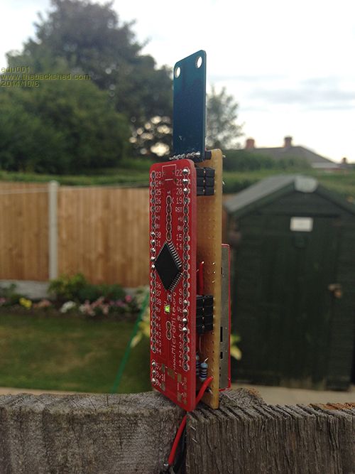
Having worked with Jed on this project; mainly power saving techniques and a complex CRC code module I am in a position to elaborate on the above and how we maximised the battery life. The 'set-up' comprises of a 44-pin MicroMite module plugged into an expansion board; the layout of which Jed takes full credit.  On this stackable expansion board is a high quality GPS receiver, a high quality RadioMetrix Radio Transmitter, a standard PCF8563 Real Time Clock, and a very efficient StepUp booster. On this stackable expansion board is a high quality GPS receiver, a high quality RadioMetrix Radio Transmitter, a standard PCF8563 Real Time Clock, and a very efficient StepUp booster.
High level operation is as follows. The MicroMite is normally in 'Sleep' mode. Periodically the RTC will wake the MicroMite which then immediately wakes the GPS module. The current GPS location is read along with some other data. The GPS is then put to sleep and the Radio Tx woken. A string of data based upon GPS co-ordinates, GPS altitude, and GPS Time is compiled and then transmitted at 50baud via the Radio Tx. The Radio is then put to sleep along with the MicroMite; ready for the next 'WakeUp'. During the time the MicroMite is awake, it is set to the appropriate CPU speed depending on the function it is performing - all in a bid to minimise average current drain. The GPS has a typical current draw of upto 20mA while 'awake', and a similar current draw for the Radio module while transmitting. On a wakeup every minute, the overall battery-life is a matter of days - remembering we can parallel batteries to provide longer flight times (but obviously at increased payload weight). This project has been very interesting to work on and hats off to Jed for an excellent combination of hardware to achieve something very impressive.
I look forward to Jed's posts as I know he has many more stories to tell you all regarding his 'flights'. 
As this is Jed's 'baby' I will let him keep you all informed with updates and will only chime in when I feel necessary! For those really interested, we will be making the hardware available to everyone very soon so that you can begin to fly your own balloons . . . . |
||||
| edu001 Regular Member Joined: 14/07/2014 Location: United KingdomPosts: 82 |
Of course! 434Mhz on 10mw is Licence Exempt and provided that you stay within 2 meter size limit at any point during the flight including the payload, you do not require a NOTAM From CAA doc CAP393 Section 1 Part 32 Page 3 Exceptions from application of provisions of the Order for certain classes of aircraft 253 (1) This article applies to: (a) any small balloon; (b) any kite weighing not more than two kg; (c) any small unmanned aircraft; and (d) any parachute including a parascending parachute. Section 1 Part 33 Page 16 'Small balloon' means a balloon of not more than two metres in any linear dimension at any stage of its flight, including any basket or other equipment attached to the balloon; |
||||
| edu001 Regular Member Joined: 14/07/2014 Location: United KingdomPosts: 82 |
That is what I read from the uBlox (google DDMM.MMMM) GPS then I do some calculations to get Decimal Degrees The flight we just did lasted 12 hours+ then went out of range it had about 40 hours battery life |
||||
Grogster Admin Group Joined: 31/12/2012 Location: New ZealandPosts: 9975 |
Very impressive - well done.
I guess you found a place where you were well out of the commercial flight-paths!
You're up with the jet engines at that altitude. 
I'm very surprised that the regs DON'T restrict you in that area - sucking your project into an airliner engine would not make you any friends at ATC(air traffic control) - quite the opposite. 
I was also very impressed with the -30 degree temperature. At that altitude, it is very cold, as you know, but I would have thought that that kind of cold may have caused the unit to fail - but it didn't - impressive test of the hardware too. Keep up the great work, and please do post back with any new projects etc. Smoke makes things work. When the smoke gets out, it stops! |
||||
| G8JCF Guru Joined: 15/05/2014 Location: United KingdomPosts: 676 |
Totally Awesome/Incredible/Fantastic/Impressive The only Konstant is Change |
||||
TassyJim Guru Joined: 07/08/2011 Location: AustraliaPosts: 6538 |
There are a lot of balloon flights in Australia. Most start from South Australia and head east. Tasmania (where I am) is too small, we would end up sending all the gear to New Zealand and have to ask Grogster to post it back. Most GPS units stop working at high altitude so you have to choose units carefully. Jim VK7JH MMedit |
||||
| paceman Guru Joined: 07/10/2011 Location: AustraliaPosts: 1329 |
Up with the rocket or scramjet engines more like it. 27,555m is close enough to 85,000ft - Wow! Commercial jets cruise at around 32-35,000ft. I think the record for a 'jet' is held by the US "Blackbird" SR71 spy-plane and as I remember it's in the 70,000's, not the 80,000ft range. That temperature actually seems a little high  for that altitude. The outside air temp that you see on the screens in the cabins of planes are often in the low -50 degree area - I assume oC. I read somewhere that temperature actually starts increasing again when you get high enough - are we up in that range? for that altitude. The outside air temp that you see on the screens in the cabins of planes are often in the low -50 degree area - I assume oC. I read somewhere that temperature actually starts increasing again when you get high enough - are we up in that range?
Greg |
||||
| edu001 Regular Member Joined: 14/07/2014 Location: United KingdomPosts: 82 |
There seems to be a cold layer at lower altitudes, this graph shows how cold it can get I tracked it to -61 but the data was erratic but the Micromite was still running I think the battery froze :) 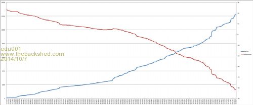
Data file 2014-10-07_062522_cold.csv.zip |
||||
| WhiteWizzard Guru Joined: 05/04/2013 Location: United KingdomPosts: 2991 |
Good point Grogs: My office is on the final approach to Heathrow (planes at 1,500ft (500m) altitude). Best I don't launch from there 
Seriously though, a little foil balloon carrying a MicroMite + expansion board would be no threat to a plane - it would simply be blown off course a bit (the balloon I mean, NOT the plane!) WW |
||||
| paceman Guru Joined: 07/10/2011 Location: AustraliaPosts: 1329 |
OK, I checked temperature out. edu001's (Jed?) balloon got to got to 25,777m which is pretty much fair in the middle of the stratosphere (12-50km altitude). Temperature does indeed start going up again when you get up to about a third of the way into the stratosphere - up till then it's been around -60C from about 12km altitude. It keeps increasing till it hits 0 deg C at the top of the stratosphere - about 50km up, so the -35oC reading he's getting at 25,777m is probably pretty close to the mark! The battery operating through these temps (to say nothing of the poor little MicroMite and the other bits) is pretty surprising. It'd be interesting to see what the battery voltage was doing through all this! This gives a good rundown: Atmosphere temp etc Greg EDIT: well I didn't need to look far, the voltage was in the log Jed gave us to download (I didn't open it till after the post). Doesn't look like the -60oC area affected it a lot at all. EDIT 2: Err... correction again; that temp log only went to 12,000m, about where jets fly, and showed 1.0 volts with air temperature at -51oC. How low can the voltage go before the supply 'carks' it? |
||||
| Page 1 of 2 |
|||||
| The Back Shed's forum code is written, and hosted, in Australia. | © JAQ Software 2026 |
